In the last post I discussed nations, states, and nation states along with a brief description of how the old kingdoms in southeast Asia understood power and territory. In today's post I'll focus a bit more on the current controversy between Indonesia and Malaysia. As I mentioned previously the area at the center attention is on the island of Borneo, specifically west of the Malaysian state of Sarawak in the Indonesian province of West Kalimantan (2). There have been accusations that some boundary markers in isolated border regions have been moved, resulting in the "loss" of around 4000 hectares of territory for Indonesia.
The Dispute

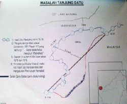
The issue is actually pretty complicated for a number of reasons. One is that the villages (Tanjung Datu, Gunung Raya, Sungai Buah, Batu Aum, and Camar Bulan, to name a few) in the area are fairly isolated and hard to access. Services like healthcare are lacking on the Indonesian side, and so in some places Indonesian citizens cross the border to buy and sell goods and go to the doctor. They've been doing this for a long time now. For example, in Camar Bulan on the Indonesian side, residents have to travel for hours to get to the nearest market town in Indonesia. The trip is expensive (more than rp400,000 or around US$50) and is contingent on tidal conditions. On the other hand, it's much easier to cross the border into Malaysia. Goods like rice and gas are much cheaper there as well. But the government of Indonesia is particularly sensitive to areas lagging in terms of economic and human development; "left-behind" areas are sometimes the targets of special campaigns and programs. The "left-behind" areas along the border draw attention because the people on the Malaysian side are relatively better off. You might conclude that this gives the government of Indonesia an inferiority complex. There have even been suggestions that the people in the area might decide to switch nationalities, which some Indonesians see as a real threat to the security of the nation.
However, as I mentioned previously, the border between Sarawak and Kalimantan is relatively new, having been decided by the Dutch and English colonial authorities in the 1800s. Even at that time, though, the border was ambiguous. The Dutch and English agreed to use natural landmarks, ridgelines, and watersheds to demarcate the border. But these natural features change, and so over the years the "line" has become more of a "zone". Not that it matters to the local people, though; most of them share the same language and culture, and many have families ties across the line. Most of the people there don't seem to feel any sort of threat; one local resident quoted in the Indonesian paper-of-record Kompas said "Biar saja...itu urusan orang Jakarta dan KL. Kita di sini damai saja": "Oh well. That's between the folks in Jakarta and K[uala] L[umpur] (the national capitals of Indonesia and Malaysia, respectively). We here are getting along fine". In fact, many Indonesians around the border are afraid that if tensions escalate, the border will be closed and they will lose access to a closer and cheaper market.
The Indonesian government has taken a firm stance on this issue. A spokesman for president Susilo Bambang Yudhoyo said that the government would not tolerate any actions that intrude on sovereignty. At the same time they make sure to point out the lack of evidence that any border markers have in fact been moved. There's more sabre-rattling in the Indonesian parliament (DPR), though. One member claims to have proof that the markers were moved and warns that Indonesia must be prepared to go to war to protect its sacred sovereignty. On the other side of the border the language isn't as heated; the Malaysian papers cover the dispute but it doesn't seem to be front page news like it is here.
The Geography of Borders

In the latter half of the 20th century, though, geographers began to look at borders more critically. Agnew (1994) warned of a "territorial trap" laying in wait for those that take borders too literally. Since the 1990s many geographers (and other scholars) have suggested that borders are becoming less important in an age of globalization. More important is the flow of goods, services, ideas, and people. However, the Indonesia-Malaysia case (and the US-Mexico border) shows us that borders and boundaries are still important. The important question is why? Arjun Appadurai writes that borders are important because they highlight the differences (and often the incompatibilities) between static nation-states and the "life-worlds constituted by relatively stable associations, relatively known and shared histories, and collectively traversed and legible spaces and places". What he means by this is that the people on the ground, and the folks at Camar Bulan are a good example of this, have patterns of making a living that exist independently from the border; to them the border only becomes important when there is a dispute between the states. It's interesting that the border is most important to those that live farthest away from it!
Other geographers describe how borders and boundaries are an important part of the way we organize the world. The University of Hawai'i's own Reece Jones (2008) describes how borders are cognitive tools. However, if we read too much into them, "the fluid and permeable boundaries of the categories...gain the appearance of fixity and permanence". Newman and Passi (1998) use the term "pedagogy of space" to explain how our experiences in school and with the media shape how we think about territory; these institutions are an important part of the "ideological reproduction of the state". This is fancy university-speak, but it means that schools, the mass media, and other institutions are all part of how our view of our own "nation" is shaped. We learn from maps, teachers, news reports. I really think there's something to this; as a youngster I remember being enamored with maps because they were a really powerful way of presenting information, and if you think about it, there are a lot of assumptions inherent in maps.
Imagined Communities?

For Indonesia the early-going was a little rough. There were significant separatist pressures in the 1950s and the future of the nation was by no means certain. The central government was faced with rebellions and other centrifugal pressures. But eventually, as years passed, "Indonesianess" was created, and today is pretty strong. Along the way, though, obstacles to the goal of creating national identity were seen as threats. This is probably part of the reason why Indonesia is so sensitive about its borders. Indonesia scholar Benedict Anderson, in his landmark book "Imagined Communities" (1983) describes how states form identities, and how we feel a connection to people we've never met just because we hold a common passport. To Anderson "nationality" creates the illusion of togetherness. This illusion is very powerful and useful to the central government, which will go to great length to preserve the illusion. So in Indonesia, protecting "Indonesia" becomes a national priority, and border conflicts get a lot of attention. Many analysts suggest that the government intentionally inflates the importance of border disputes to distract attention away from its failure to tackle problems such as corruption, poverty, and poor infrastructure.
As a neutral observer, I have no comment on this last point :).
Notes
(1) "Our heads and stomachs are in Indonesia but our stomachs are filled by Malaysia".
(2) Indonesians call Borneo "Kalimantan"
References
Newman, David, and Anssi Paasi. 1998. Fences and Neighbors in the Postmodern World: Boundary Narratives in Political Geography. Progress in Human Geography 22:2 pp186-207.
Starr, Harvey. 2006. International Borders: What Are They, What They Mean, and Why We Should Care. SAIS Review 26:1 pp3-10
I can understand the government wanting to have a defined boundary. It seems that the conflict is the government's and not the people that live in the border zone. The people near the border probably identify and feel that they are Indonesian. However, these Indonesians may feel that there government is not caring about their welfare because they are more worried about a border line and not them getting food and going to the doctor.
ReplyDelete