Tuesday, September 21, 2010

BEWARE The Queen of the Deep...and other tales...


A couple of weeks ago I decided to go out looking for surf, because it had been too long since I was last in the water. As you may know, Indonesia has some great waves. Unfortunately most of the famous sites like Nias and G-land seem to be too far from Jogja. So I decided to seek out something a little more local. There is a beach about 25 kilometers (1) south of here that many of the locals go to. I'd been there before and the waves looked decent. So I asked around among my friends. "Does anyone surf Parangtritis?" I asked.

"Oh no...it's much to dangerous", they said. "There are very strong currents and many people drown there". As a general rule, it's a good idea to trust the local knowledge of the water, and so I decided to look elsewhere. As it turns out, there's more than the current that makes Parangtritis dangerous: the Queen of the Deep Nyai Roro Kidah. I've included a picture of her, and no, I didn't take this picture myself.

Apparantly Queen Roro is pretty feisty. Every year the Sultan (2) of Jogjakarta brings an offering to the beach and sets it afloat to keep her happy. According to legend, Queen Roro was once married to the king of the Mataram kingdom. However. a jealous rival cast a spell on her, causing her majestic beauty to fade and wither. She fled the kingdom in shame and threw herself into the ocean, where she was saved and given a castle beneath the sea and her beauty restored. Here she rules over all the creatures of the sea. The legends say that the Sultan of Jogjakarta is supposed to marry the queen, which gives him power over the land. But swimmers beware...if she or one or her minions catches you in the water you will be taken to her underwater world, never to be seen again! Sometimes she even comes ashore for her victims. There's a way to protect yourself though (on land, at least): don't wear the color green, as this is the color her long lost love will wear when he comes back for her. If she sees you wearing green, she may drag you to her watery realm.

I did finally find some surf, but I'll save that for another post...


Another great story that is told through dance and wayang (traditional puppet shows; the picture shows an example of a wayang kulit shadow puppet) is the Ramayana. This is an ancient Hindu story. Hinduism is one of the world's major religions, practiced by almost a billion people. Though it originates in India (3), Hinduism spread to Indonesia more than 1500 years ago and was the official religion of some of the early Javanese kingdoms. The Ramayana tells the story of Prince Rama, whose wife is kidnapped by the evil demon-king Ravana, who takes her back to his island of Langka. Prince Rama embarks upon a journey to rescue his wife, aided by his magical friend Hanuman, a giant white monkey that can change his shape and size. The story tells about their journey and their battle against the evil armies of Langka. It's a really great adventure, and you can see and read about many different versions of the Ramayana from all over the world. When you come to Jogja make sure you catch the dance performance of the Ramayana in front of the ancient Hindu temple complex of Prambanan.

That's all for now...I'm off to sleep to dream about magical monkeys and undersea kingdoms! While you wait for the next post, why don't you have a look at the following questions. Then you can watch the flash-animation story of Queen Roro I borrowed from youtube. Although it's in Indonesian, you can get the idea of the story while listening to some traditional Javanese music. Can you make up your own text of the story? What do you think is going on?

1. Kilometers are the unit of distance used in most of the world outside of the US. There are approximately 1.61 kilometers in a mile, and one kilometer is approximately .62 miles. Can you figure out how many miles 25 kilometers (km) is?

2. The Sultan is the ruler of Jogjakarta. The Sultan comes from a royal family, and Jogjakarta is the only place in Indonesia where the Sultan actually has political power. The Special Province of Jogjakarta is his domain, and he also serves as governor of the province.

3. Can you find India on a map? What can you find out about Hinduism?

4. Do you know any stories from Hawai'i like these?


Monday, September 20, 2010

Why Are There So Many Volcanoes Here?


One of the first things you notice in Indonesia is the topography. The islands of this country are dominated by volcanoes. Here in this picture taken from the space shuttle you can see several of the volcanoes that dot the island of Java (look for the clouds; the clouds are related to the mountains, but we'll save that for another blog post). Visitors first see the volcanoes from the air as they approach Jakarta or Jogjakarta (see the picture below my blog posts). Here in Jogja we have an everyday reminder of the volcanic nature of these islands: Gunung Merapi (gunung means "mountain" in Indonesian; volcano is gunung api; "fire mountain"). You can see Gunung Merapi in the picture I've included. It constantly emits a trail of smoke. These volcanoes are responsible for the remarkably beautiful and unique scenery you'll see when you come to Indonesia. Ive included a picture of Bromo National Park in Eastern Java so you can see what I mean. There's also a major volcano near the spot where I am doing my PhD project on the island of Sumatra.

But the volcanoes have a dangerous side too, as you can well imagine. Frequent eruptions force many people to flee their homes, ash, gas and other debris expelled from volcanoes cause health problems, and from time to time people are killed by lava flows. In addition to the volcanoes, there are earthquakes, which are sometime accompanied by related events, such as the devastating tsunami of 2004. You may recall from my post about Borobudor that volcanic eruptions and earthquakes were at least partially responsible for the abandonment of the monument.

What causes these volcanoes and earthquakes? The answer lies in the very nature of the earth itself. The surface of the earth, or crust, is similar to the shell of an egg. It is very thin, and beneath it is liquid rock, or magma which is extremely hot because of the intense heat of the interior of the earth. However, the crust differs from the shell of an egg in that it is divided into a number of different pieces. Geographers, geologists, and geophysicist call these pieces plates. There are around 14 big plates and a number of smaller plates. I've included a map so you can see the different plates (1).


These plates don't just sit still; they move around, and when they do they bump into and slide against one another. As you can probably imagine, since the plates are so big and heavy this creates a lot of pressure and force which is expressed in the form of an earthquake. That's right, whenever there is an earthquake, it means the earth is adjusting its "shell". Now, look at the map of the plates. Can you find Indonesia on this map? What do you notice about it? That's right, it right at the meeting point of two plates. In fact, the Australian Plate is actually sliding beneath the Eurasian Plate. This isn't just a coincidence; Indonesia was actually created by this process. When one plate slides under another, the plate sliding beneath is actually melted by the intense heat under the surface of the earth. And whenever something melts or burns, there is always exhaust of some kind or another. This "exhaust" makes its way up to the surface of the earth and creates a volcano. In addition, some of the plate that is being forced below is actually scraped off and becomes part of the plate that remains on top. This entire process is called subduction, and the place where it happens is called a subduction zone. I've included a diagram so you can get an idea of how this works. As you can see, Indonesia is in the heart of a subduction zone.


Now, let's see if we can figure out how this affects the landscape. Below I've included a physical map of Indonesia. Geographers use physical maps (3) to show features of the landscape. On most physical maps elevation is shown in brown; the browner the area, the higher it is. At the same time, depth in the ocean is shown with shades of blue. The bluer the color, the deeper the ocean. See if you can identify some mountainous areas, flat areas, and deep areas in the ocean. Now think about the map of the plates, and look at the diagram of the subduction process once again. Can you see the physical evidence of the plates interacting with one another? You might notice a chain of mountains that run from the north of Sumatra all the way across the island. This is the product of subduction.

When you come to Indonesia you can see the evidence for yourself. It's truly breathtaking and gives you a new understanding of the dynamic nature of the planet. I'll write more later, but in the meantime you might want to think about the questions I've provided below.

1. What plate is Hawai'i on?

2. Look at the map of tectonic plates and identify some other places where plates meet. Now find a physical map of that location using the internet, classroom resources, or the library. What sorts of landforms do you find at these locations?

3. What types of things might a physical map be very useful for? Can you think of some other types of maps?

Sunday, September 19, 2010

My Favorite Place To Eat...


One of the best things about traveling to another country is trying all the different types of food. This is especially true with Indonesia because it's such a wonderfully diverse nation. Indonesia has more than 17,000 islands, and the distance from one end of the country to the other is about the same as the distance from New York City to Los Angeles! (1). And much like the United States, within this country there is an incredible amount of cultural diversity. This means that there are all sorts of different types of foods to try. It's worth coming here just for the food!

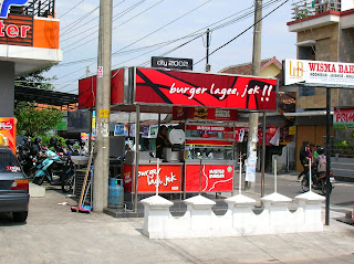
Today I want to tell you about my favorite place to eat here in Jogja. Every time I come here I have to eat at this place (usually several times!), and when I'm back in Hawai'i I miss the food. I took a picture of the "restaurant" so you can see it. Dining out in Indonesia is a bit different than in Hawai'i....while there are many restaurants like you're probably used to, there are other options as well. These include warungs (food stalls) and pushcarts, like the one you see in the picture. These pushcarts are called "PKLs" or "pedagang kaki lima" (five-legged traders) in Indonesia. Can you figure out where this name comes from?

My favorite place serves a delicious entry called bakso. This is a meatball and noodle stew that is very popular here. I've sampled bakso from pkls, warungs, and restaurants all over Jogja, and this place is my favorite. And it's a local favorite as well; the woman that makes the bakso has been serving her specialty at this same place for 25 YEARS! People come from all over to eat at this pkl, and she dishes out hundreds of bowls a day. Her whole family is involved in the operation as well...her nephew generally works the cart, and her sons prepare the meatballs and other ingredients from scratch everyday. To make the meatballs, Juni (my friend and one of the sons) starts with 25 kilograms of beef (2) which he buys at a local market. He then takes the beef to another shop where they grind it up with a special industrial grinder. During this process he adds special spices that give the meatballs their distinctive taste. Back at home he makes all the meatballs by hand, which generally takes 2-3 hours. The other ingredients are made by hand from fresh ingredients each day as well. You can enjoy your bakso with a nice refreshing glass of jus jeruk (citrus juice) and for desert have a bowl of iced fruit. In the picture you can see how the iced fruit is made.

Dining at the PKL is not just about the food. Every time I sit down for a bowl (usually 2) of bakso I meet someone new and always have an interesting conversation. It's a good way to practice the language and make new friends. The people here are always curious as to what I'm doing in Indonesia and are always eager to teach me something new about the country or some words in the local language (do you remember from the previous posts what the local language around Jogja is?).

Of course there are other options as well. You can try masakkan Padang (Padang cuisine, named for the city from which it originates), soto (another delicious soup), rendang (a famous beef dish), and many others. One thing you know when you come to Indonesia is that you'll never go hungry.

If you're not the adventurous type you can find many familiar foods as well. Indonesians love fried chicken, and the pizza is pretty good as well. And if your in a hurry you can try Mister Burger, but I haven't quite figured out what the burgers are made of...

1. Can you use a map in the classroom to figure out the distance from New York City to Los Angeles?

2. A kilogram equals 2.2 pounds. "Kilograms" are used in most of the world for mass. Can you figure out how many pounds 25 kilograms equals? Can you figure out how much you weigh in kilograms?

Saturday, September 18, 2010

Off To Borobudor!


I took a little weekend trip to Borobudor, the largest Buddhist monument in the world! Borobudor is about an hour away from Jogja, so I had to rent a motorcycle. Traffic is very different in Indonesia; there are many many more motorcycles and scooters on the road than cars, and sometimes you see a motorcycle carrying a whole family! The traffic here also doesn't really follow the lane markings in the road; it flows much more organically. And it seems like, for Indonesian drivers, what is behind is not really important. But once you get used to it it's easy to get around.

But back to Borobudor. It's a pretty neat place. It was built in the 9th century by the Sailendra kingdom, a dynasty of rulers here that very actively promoted the spread of Buddhism. The construction of this massive temple is estimated to have taken 75 years! I've included a picture of one of the stone reliefs; these go all the way around the temple in two layers and tell in pictures about the life of Buddha, the founder of Buddhism. Borobudor was intended to be a destination for pilgimages, which are journeys to sites of religious importance. The pilgrim would walk around each of the levels of the temple to follow the story of Buddha.

It's really hard to imagine, but for a long time this giant monument was unknown to that outside world! At some point about 1000 years ago the temple was abandoned as the kingdom moved to another part of the island of Java, far from Borobudor. Now remember one of the major features of this island...it is very volcanic. So over the years, volcanoes erupted and covered the area around Borobudor. Later lots of trees and thick bushes moved in as well, because volcanic land is very fertile. This is because volcanic soil is full of minerals that help plants grow.

But the monument was not forgotten completely by the locals (who could forget something like Borobudor), and when the British briefly gained control of the island of Java it was "rediscovered" around 1820. The Dutch, who were the colonial governors of Indonesia, investigated Borobudor and sent expeditions to catalog and describe the temple. However, as word spread international collectors also became interested in Borobudor, and as a result parts of the temple were stolen by treasure-hunters.

Indonesia became independent in 1945 and assumed the responsibility of preserving and restoring Borobudor. Now the monument is the most-visited site in Indonesia, welcoming over 2 million guests a year! I can tell you, it's definitely worth the trip!

1. What is Buddhism? What are the major beliefs of Buddhism? Where was it founded and where is it mainly practiced now?

2. What do you remember from the blog post about volcanoes and land? Can you think of any examples in Hawai'i?

Check out the neat video tour from Indonesia's Tourism Ministry:
http://www.youtube.com/watch?v=lgONItFMHe8&feature=related

Friday, September 17, 2010

Becak Becak Becak!


Ah the becak...one of the characteristic sites of Jogjakarta. A becak (bay-chak) is a common form of transportation here. Becaks are a type of pedicab(1); that is, the driver propels the vehicle with his own power, in this case his feet. Other types of pedicabs include trishaws and bicycle rickshaws. You may have seen one of these vehicles rolling around Waikiki or Ala Moana.

It's simple to ride a becak in Jogja. In most cases, you don't even have to look for one, because they will find you. Tell the becak driver where you want to go and he will quote a price. Make sure you have your bargaining shoes on, because the first price is never the final price. Sometimes the final price is less than half the first price quoted by the driver. If it's raining though you can expect to pay a little more. And it's more expensive to go uphill than downhill! But for most people the becak represents an affordable and efficient way to get around.(2)

Riding a becak is great fun and an excellent way to see the city. It's also a good way to pick up some bits and pieces of Javanese, the local language that is spoken by many people in this city. But this form of transportation is not without problems, both for the operator and the city at large. Becak drivers don't make very much money. The average day's wage for a becak driver is around 30,000 rupiah (the unit of money in Indonesia). While this may sound like a lot, think about it this way: there are approximately 9,000 rupiah in one US dollar. Can you figure out how much the becak driver earns in a day in dollars? Can you imagine trying to live on this much money every day?

Another problem is crowding. There are an estimated 6,500 becaks operating with permits in Jogja alone, with perhaps another 1,000 without permits. Becak drivers are often criticized for blocking traffic. Indeed the use the same streets as cars and motorcycles, and on narrow roads they can slow things up quite a bit. There have been proposals to limit the number of becaks on the road as well as the hours of operation. Some have suggested banning becaks from some areas or even eliminating all of the becaks. In fact, Indonesia's capital city (can you remember what the capital of Indonesia is?) banned becaks years ago to improve traffic.

1. ped- words usually refer to the feet (latin roots) or children (greek roots)...what do the following words have to do with feet or children?
a. pedestrian
b. pedicure
c. pediatrician
d. pedal
--Can you think of some other examples?

2. In addition to being affordable and efficient, can you think of some other benefits becaks provide?

Check out the National Geographic video I included from Youtube. What do you think?

http://www.tempointeraktif.com/hg/bisnis/2010/06/10/brk,20100610-254271,id.html
http://www.karbonjournal.org/focus/perjalanan-becak-perjalanan-kota-benarkah-becak-yogyakarta-masih-raja-jalanan
http://www.youtube.com/watch?v=_w3k311tgEs

Thursday, September 16, 2010

Will it Ever Stop Raining?


It's raining again! It seems like it's been raining everyday here in Jogja, and that makes it very humid here. It rains a lot because this is a tropical location (like Honolulu) and an island. However, under normal circumstances there is a dry season and a wet season, again much like Honolulu. Think of your experiences. When does it usually rain in Honolulu? When is it generally dry? The pattern matches this area of Indonesia as well. Climatologists (people that study long-term weather and atmospheric trends) refer to this dry-wet season pattern as a monsoon. Many people think that monsoon means "lots of rain", but this isn't exactly true. Monsoon refers to a seasonal shift in winds. This means that during one season the prevailing wind blows from one direction, whereas during the other season the wind blows from a different direction. Probably the most well known example of a monsoon pattern is India. You may have seen stories on the news or in National Geographic about the monsoons there. In India for part of the year the wind comes from the north, which is all land and mountains, so there isn't much rain. However during the other part of the year the wind brings air from the Indian Ocean and Bay of Bengal (find these on a map), and so the air is very moist and thus there is rain.

The monsoon is important for farmers but it has also been important historically for global trade! Find Indonesia on a map. Now locate India and China. You can see that Indonesia is about in the middle of the sea route between these two nations, which are home to ancient civilizations. Hundreds of years ago, before steam and diesel engines sailing was the best way to go long distances, especially with heavy cargo. The interesting thing about Indonesia is that the monsoon winds actually aided trade. For part of the year the winds blow towards Indonesia, making it easy to go from China or India to Indonesia. Then for the other part of the year the winds blow away from Indonesia, making it easy for Chinese and Indian traders to get home!

These islands in the past have been referred to as the "Spice Islands". That's because this is the natural home of many spices like black pepper, nutmeg, cloves, and many others! You are probably very familiar with some of these, but just a few hundred years ago in Europe these spices were virtually unknown. When they were discovered by Europeans a huge demand was created. Can you imagine eating food without pepper or other spices? The demand for spices from what is now known as Indonesia was so great that these spices for a time were worth more than gold! Monsoon winds helped stimulate the trade between Indonesia and Europe.

The problem these days though is that the monsoon seems to be getting less reliable. Indonesia is an agricultural country, and rice is the major crop. It is very productive, especially in the tropics. However, it needs regular and plentiful water for maximum yields. The other day I was talking to a farmer (in Indonesia), and he told me that global climate change (sometimes referred to as "global warming") seems to be disrupting the monsoon. When it rains unexpectedly the crops are damaged, and the farmers get confused as to when to plant new rice. Now back to my first point...the rain... Remember I said that Indonesia (like Hawaii) has a dry season and a wet season. The problem is that now it's supposed to be the dry season! So it's not just me that's asking this question...the farmers are too.

I'll write more soon, but in the meantime you might want to try to answer some of the questions I've included below.

Can you find a climate map that shows where monsoon climates are found? Try using the internet. Can you find some stories about the relationship between global climate change and shifting monsoon seasons?

What do I mean when I use the term "tropics"?

Monday, September 13, 2010

The Holiday Season in Jogjakarta!

Well, I've finished my language study. 6 weeks! Now it is time for me to go to Sumatra and do some research work. Right now is a special time in Indonesia because it is the end of Ramadan, which is a very important month for Muslims. Most of the people in Indonesia are Muslims; in fact, Indonesia is the largest Muslim nation on the planet in terms of population!

During the month of Ramadan Muslims do not eat or drink from sunrise to sunset. In this way they show their devotion to Allah (God) and cleanse themselves spiritually. At the end of the month there are big feasts, and most people return to their villages or their family homes, so it is very difficult to travel. In fact, I am having a hard time finding a ticket back to Jakarta, the capital city. I may have to ride a horse!

I will write more soon. But maybe you can find some information about Muslims and Islam in the mean time...